Discover the Rossana Maiorca Cycle and Walking Path in Syracuse: a route between sea and archaeology
- veronicameriggi
- Aug 16, 2025
- 5 min read
The Rossana Maiorca cycle and walking path in Syracuse connects the urban centre with the northern coast, following the route of the old Syracuse–Targia railway. Today the disused railway line has been transformed into an itinerary that combines sea, nature and historical landmarks. Along its kilometres you come across archaeological remains, coastal views and points of interest that tell the story of Syracuse. It is a route accessible both by bike and on foot, suitable for those looking for a simple but meaningful way to get to know the area.
Origins and history of the route (former Syracuse–Targia railway)
The Rossana Maiorca cycle path in Syracuse was created from the recovery of the old railway line that once connected Syracuse to Targia. The railway, inaugurated in 1871, remained active for over a century until it was closed in 1998, when it was replaced by the new tunnel route.
In 2008 the abandoned line was converted into a cycle and walking path about 6.5 km long, with access points from different areas of the city. The transformation gave back to residents and visitors a route that combines sustainable mobility, green spaces and a historically rich setting.
Also in 2008, the year of its inauguration, the path was dedicated to Rossana Maiorca, an apnea champion and daughter of Enzo Maiorca. Born in Syracuse and holder of several world records in the 1970s, Rossana is remembered as one of the most prominent Italian athletes in her discipline. The decision by the Municipality of Syracuse to dedicate the cycle path to her was a way of linking this route to the sea and to the sporting tradition of the city. Along the route, several information panels recall her achievements and her contribution to the spread of underwater sports.

Route features
The Syracuse cycle path is easy to travel and accessible to different types of users. Its moderate length, regular surface and multiple access points make it a practical choice both for cyclists and for walkers.
Length and surface
The route runs for about 6.5 km along the northern coast of Syracuse, following the old railway line. The surface is partly asphalted and partly gravel, making it suitable for trekking bikes, mountain bikes and e-bikes. The path is flat and linear, with some sections offering rest areas and sea views.
Access points and recommended starting areas
The main access points are located in several areas: from the former Syracuse Umbertina station, along Via Elorina and in the Santa Panagia area. Each access allows you to enter the route and travel in both directions, choosing whether to cover the whole path or just a section. Near the entrances there are areas where you can park your car and reach the path on foot or by bike.
Accessibility: suitable for families, e-bikes and walks
The path is flat and free of traffic, making it suitable for families with children and for those who prefer a quiet walk. It is also popular with people using e-bikes, scooters and with dog owners. Short, safe and linear, the route works both as a daily pedestrian path and as a light cycle tourism itinerary.
What to see along the Rossana Maiorca cycle path
The Rossana Maiorca cycle and walking path is not only a route to cycle or walk, but also an itinerary that crosses places of historical, archaeological and artistic interest. Along its kilometres you encounter landmarks that tell different periods of the city, from antiquity to the present day.
The Tonnara di Santa Panagia and the Latomie dei Cappuccini
One of the most striking points along the route is the Tonnara di Santa Panagia, a complex linked for centuries to tuna fishing and today an important reminder of the economic and social memory of Syracuse.

Not far away are the Latomie dei Cappuccini, stone quarries used since the Greek era, showing the ancient connection between the city and its territory.
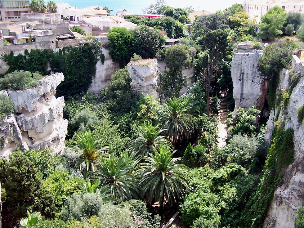
The Dionysian walls and the Second World War bunkers
The route runs alongside sections of the Dionysian walls, built in the Greek period to defend Syracuse and considered among the most imposing fortifications of the ancient Mediterranean.
In the same stretch you also encounter Second World War bunkers, more recent structures that show how this area continued to be used for defence purposes in modern times.

The Sculpture Park: open-air contemporary art
Since 2015 the path has also hosted the Sculpture Park, a permanent exhibition space created thanks to a European project. Along the route you can admire works by contemporary artists that interact with the natural environment and with the city’s historical past. It is an example of how the path has also become a place of culture and artistic experimentation accessible to everyone.
Why take an excursion on the Rossana Maiorca cycle path
The Syracuse cycle and walking path is not just an urban link but an itinerary that brings together in a few kilometres several aspects of the territory. Walking or cycling here means moving along the northern coast of the city without traffic, on a safe route that combines archaeology, historical memory and natural spaces.
It is a convenient option for those who want to enjoy cycle tourism in Sicily, but also for those who live in or visit Syracuse and are looking for an activity accessible on foot or by bike. The path allows you to alternate movement and breaks, turning a simple ride or walk into an opportunity to discover places often left out of traditional tourist circuits.
Practical tips for visiting the Rossana Maiorca cycle path
Planning a trip on the Syracuse cycle path is straightforward, but a few practical details can make the experience even better. Here are useful tips on timing, access points and available services.
Best time to go and average duration
The path can be used at any time of year, but the most pleasant seasons are spring and autumn, when the weather is mild. In summer it is better to go early in the morning or late in the afternoon, as some stretches are not shaded.
The duration depends on your pace: by bike it takes around 30–40 minutes to cover the 6.5 km route, while on foot it takes about an hour and a half to two hours.
How to get there, parking and access points
The main entrances are located near the former Umbertina station, along Via Elorina and in the Santa Panagia area. In the vicinity there are unattended car parks from which you can easily reach the path.
From Ortigia or the historic centre, you can reach the access points by bike by crossing the Ponte Umbertino and continuing along Viale Montedoro to Via Elorina, or following Corso Umberto towards the northern part of the city. This way you can reach the route without using a car.
Where to rent bicycles
There are several bike rental points in Syracuse, offering both traditional and electric bikes. For those staying in Ortigia, a convenient option is Hotel Algilà, which provides its guests with an e-bike rental service. Alternatively, in the city you can find shops and local operators renting trekking and mountain bikes for the whole day.
Tips for those travelling with children or pets
The route, flat and traffic-free, is suitable for families with children. It is advisable to start from the nearest access points and cover only short stretches, stopping at panoramic spots.
The path is also popular with dog owners: dogs must be kept on a leash, and the absence of cars makes the walk safe.


Comments